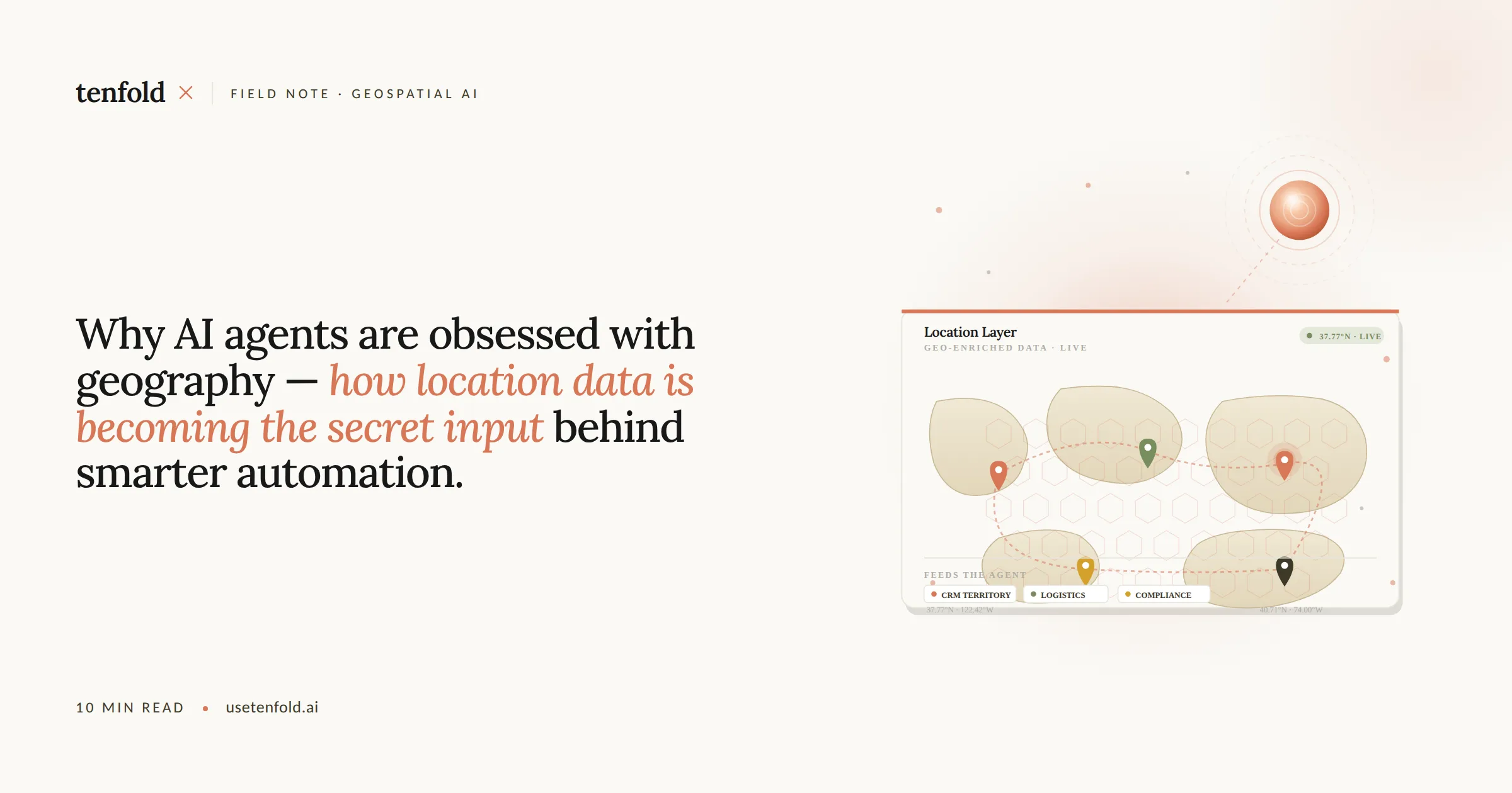
Why AI Agents Are Obsessed With Geography: How Location Data Is Becoming the Secret Input Behind Smarter Automation
Location data is no longer a logistics problem. It's an intelligence problem — and AI agents are the ones solving it. Most enterprise automation discussions focus on data volume, model capability, and workflow orchestration. What they miss is the spatial layer: the *where* that transforms a competent AI action into a precise, contextual one.
Quick Answer: AI agents use location data to make decisions with real-world context — routing leads to the right sales rep, flagging supply chain risks by geography, prioritizing customers near high-density service areas, and triggering region-specific compliance actions. Organizations that feed their agents a geospatial layer aren't just automating tasks. They're automating judgment.
Key Takeaways:
Nearly 80% of all business data contains a geospatial component — most organizations are ignoring it in their AI agent design.
Optimizing sales territories with location intelligence has been shown to increase sales by up to 7% and improve sales productivity by 10–20%.
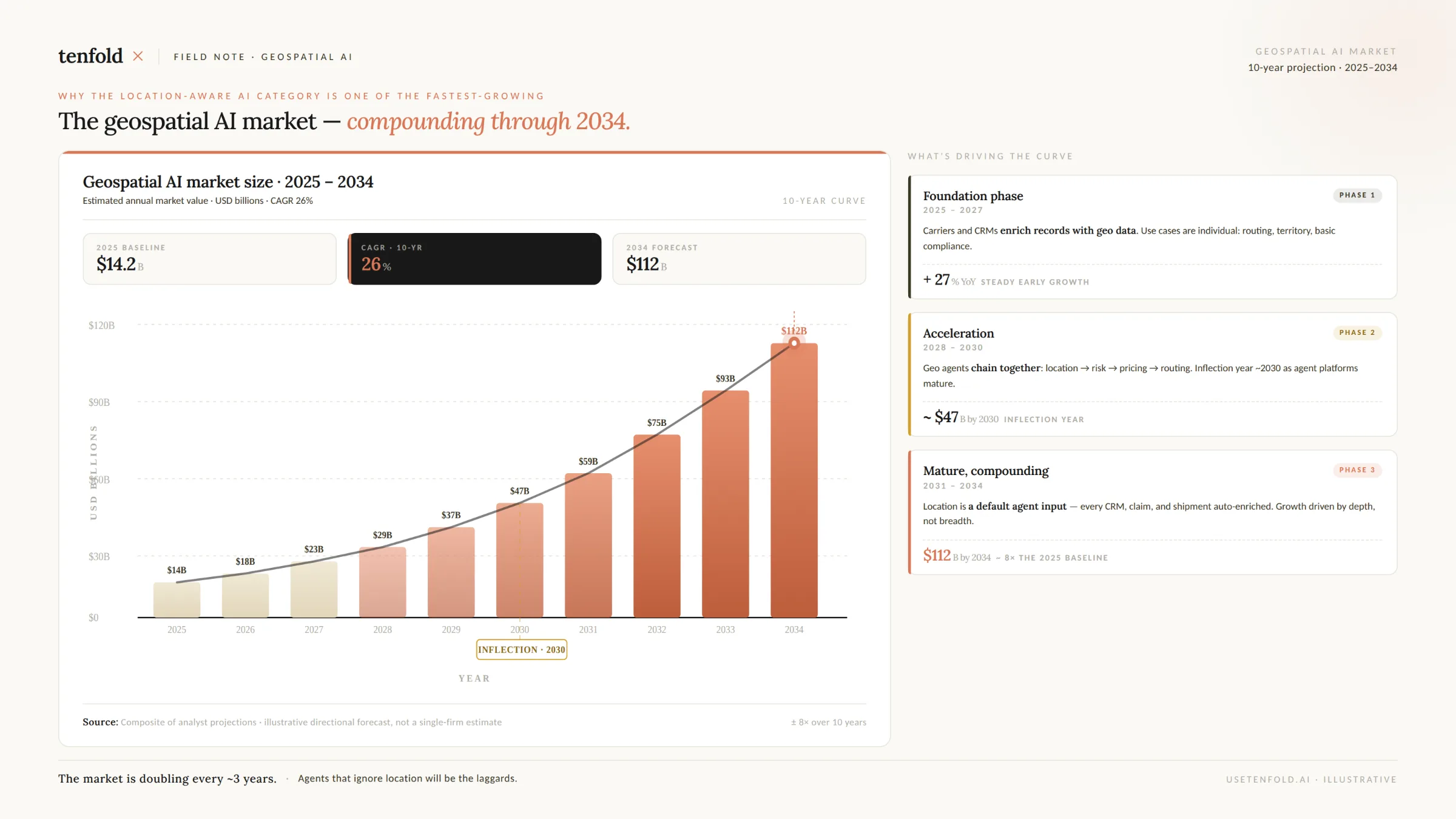
The global geospatial AI market is on track to reach over $64 billion by 2030 — with enterprise adoption moving from defense and government into commercial operations at speed.
Major cloud platforms — Google, AWS, and Microsoft — have all moved to natively embed location intelligence directly into their agentic AI infrastructure in 2025.
AI agents with geospatial grounding make faster, more defensible decisions — and that's the advantage most ops leaders haven't yet operationalized.
The 80% Problem: Your Business Data Has a Location Layer You're Not Using
Here's the real gap in most enterprise AI programs: they treat data as flat when it isn't.
According to geospatial technology experts, nearly 80% of all business data contains a geospatial component — yet when organizations stand up AI agents, they wire them to CRM records, support tickets, and financial reports. The location dimension gets stripped out or ignored.
That's not a minor oversight. Location context changes what an AI agent should *do* with a piece of information. A lead in a suburban zip code gets routed differently than one in a dense urban metro. A supply chain disruption in Southeast Asia demands a different response than one in Western Europe. A service request 2 miles from your nearest field technician has a different priority than the same request 47 miles out.
According to Janea Systems' analysis of the geospatial AI market, nearly every category of enterprise decision-making — from resource allocation to customer outreach to infrastructure monitoring — becomes demonstrably more accurate when the spatial layer is present.
The bottleneck isn't AI capability. It's that most organizations aren't yet architected to feed location data into the agents making their decisions.
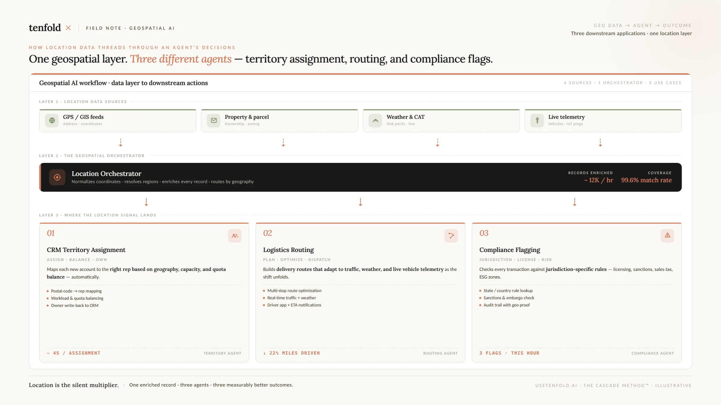
What Geospatial Grounding Actually Does for an AI Agent
Geospatial grounding isn't a feature — it's a decision-quality multiplier. Here's what changes when your AI agents can reason spatially.
Territory-Aware Lead Routing
AI agents in CRM systems already route leads automatically. But territory rules are where geography becomes the governing logic. According to research cited by Cohesive AI, optimizing territories with mapping technology has been shown to increase sales by up to 7% and improve sales productivity by 10–20% — through better coverage, balanced workloads, and reduced travel overhead.
The mechanism is straightforward: AI agents can route leads based on territory, industry expertise, deal size, or product interest, with the system factoring in rep availability, current workload, and past performance with similar accounts in similar geographies. Companies using AI-driven territory routing report significantly faster response times when compared to manual SDR assignment.
This isn't just a routing convenience. For enterprise sales organizations with hundreds of reps across multiple regions, geospatial routing is the difference between a lead landing with the right person in 90 seconds or sitting unassigned for hours.
Real-Time Spatial Analysis in Agentic GIS Workflows
Beyond CRM, the emergence of what practitioners call "agentic GIS" marks a structural shift in how organizations perform spatial analysis. Integrating artificial intelligence as autonomous agents within geographic information systems enables automated data retrieval, spatial analysis, and map generation with minimal human input — tasks that previously required specialist GIS teams to handle manually.
Researchers at Penn State demonstrated this concretely: their proof-of-concept AI agents retrieved geospatial datasets, performed spatial analysis, and generated maps with minimal human intervention. A data retrieval agent called LLM-Find automatically fetched datasets based on natural language requests — pulling sidewalks, road networks, school locations, and remote-sensing imagery for a school walkability assessment in minutes.
GIS Copilot, their integrated multi-agent assistant, achieved an 86% success rate across more than 100 multi-step spatial tasks — including advanced unguided tasks that previously required expert-level GIS knowledge.
The implication for enterprise operations: the spatial analysis that used to require a specialist and a week's lead time can now be delegated to an agent. That's a structural change in who gets access to location intelligence — and when.
Supply Chain and Logistics Intelligence
Location data is also reshaping how AI agents manage supply chain decisions. AWS built a Logistics Agent on Amazon Bedrock in partnership with Singapore's A*STAR, enabling supply chain teams to query shipping updates, weather data, and impacted purchase orders in natural language — with the agent providing actionable recommendations rather than just data retrieval.
According to AWS, this Logistics AI Agent allows supply chain teams to engage in natural language, understand organizational context, identify the right data sources automatically, and make conclusions or recommend next best actions using AI reasoning. The location context — knowing *where* a disruption is happening relative to alternative sourcing, inventory positions, and delivery commitments — is what makes the agent's recommendations actionable rather than generic.
The Platform Infrastructure Is Already There — Most Enterprises Just Haven't Plugged In
The major cloud platforms made a decisive move in 2025: they embedded location intelligence natively into their agentic AI infrastructure. The capability exists. Most enterprise teams just haven't configured their agents to use it.
Google's Gemini Enterprise Agent Platform is designed for native grounding using Google Maps' unique, high-fidelity data. According to Google's own documentation, this capability instantly contextualizes AI applications and agents with information on over 300 million places, providing the local and geospatial insights necessary for accurate modeling, resilient operations, and informed decision-making in the physical world.
In practice, this means a Google Retail Location Strategy Agent — already demonstrated publicly — can use Gemini 3 to orchestrate Google Search and Maps alongside code execution to synthesize data into comprehensive location strategy reports, automatically.
On the AWS side, Amazon Web Services linked its Location Service with Bedrock in July 2025, enabling natural-language spatial queries for supply-chain and climate-risk use cases. AWS's Bedrock also integrated GraphRAG capabilities with Amazon Neptune Analytics — allowing AI agents to model relationships in spatial data, such as connectivity in transportation networks, and query them with greater context awareness.
Microsoft Azure Maps expanded to 60 regions in September 2025, improving latency for autonomous-vehicle and industrial-automation workloads.
The infrastructure message is clear: the three dominant enterprise cloud providers have all moved location intelligence from an optional add-on to a first-class citizen in their agentic AI stacks. The question for operations leaders isn't whether this capability exists — it's whether your agents are using it.
The Market Is Moving Fast — Enterprise Adoption Is the Gap
The commercial signal behind this shift is significant.
According to MarketsandMarkets, the geospatial intelligence market is projected to grow from $37.13 billion in 2025 to $62.88 billion by 2030, at a CAGR of 11.1%, driven by wider use of location-based information and accelerating AI adoption across public and private organizations.
Broader market estimates are even larger. According to Precedence Research, the global geospatial analytics market is predicted to grow from $105 billion in 2025 to approximately $338 billion by 2034, growing at a CAGR of 13.9%. That growth reflects demand across smart cities, transportation, retail, financial services, and healthcare — all increasingly powered by AI agents rather than human analysts.
The BFSI sector specifically is emerging as the fastest-growing enterprise segment for geospatial AI adoption. Financial institutions are increasingly leveraging geospatial AI for fraud detection, location-based risk assessment, credit profiling, and branch network optimization — use cases where the spatial layer directly improves the quality of an AI agent's risk decision.
Brands that combine spatial data with CRM systems report a 30–50% increase in ROI on omnichannel campaigns by concentrating efforts on high-potential areas and reducing unnecessary spending — a figure that underscores the commercial case for geospatial intelligence integration beyond traditional mapping use cases.
What This Means for How You Build AI Agents
Location data changes the architecture of an AI agent — not just the output quality. Here's how that plays out practically.
Context enrichment at intake. When a lead, a service request, or a procurement order enters your system, a geospatially-grounded agent can immediately augment that record with relevant location attributes — proximity to sales territories, risk levels by geography, regional compliance requirements, and local market conditions. This happens before any decision logic fires.
Dynamic territory and routing logic. Static territory rules built in Salesforce assignments become dynamic when location intelligence is live. An agent with geospatial grounding doesn't just match a zip code to a rep — it weighs proximity, workload, historical win rates in that geography, and current travel overhead simultaneously.
Spatial triggers for downstream automation. Location events — a new competitor store opening in a territory, a weather event in a supply zone, a concentration of churned accounts in a particular region — can become triggers that fire agent workflows automatically. This is how location data stops being a reporting metric and becomes an operational input.
Compliance and data sovereignty awareness. Geospatial grounding also forces responsible architecture. Under GDPR and CCPA, location data counts as personal information, requiring explicit consent and minimized storage. The EU AI Act classifies real-time biometric identification tools using spatial data as high-risk. Your agent architecture needs to know *where* it's operating — and govern data handling accordingly.
At Tenfold, we've found that when organizations first map their agent workflows against the spatial layer, they consistently discover three to five high-value automation opportunities they weren't aware of. The location dimension is that reliably underutilized.
Summary
AI agents make better decisions when they know where they are. Geography isn't a niche input for logistics teams — it's a foundational context layer that sharpens every category of AI agent decision, from CRM lead routing and territory management to supply chain risk and real-time spatial analysis. The infrastructure to enable geospatial grounding is already embedded in the platforms your organization likely uses. What's missing in most enterprise deployments isn't capability — it's configuration. At Tenfold, we specialize in designing agent architectures that are context-complete from the start. That includes the spatial layer most vendors and consultants still leave on the table.
Frequently Asked Questions
Q: What is geospatial grounding for AI agents?
A: Geospatial grounding is the practice of feeding location-aware data — coordinates, territories, proximity relationships, regional attributes — into an AI agent's decision context. Rather than treating data as flat records, geospatially-grounded agents understand *where* something is happening and factor that into their recommendations, routing decisions, and triggered actions.
Q: How does location data improve AI agent performance in CRM and sales?
A: Location data enables AI agents to route leads to the correct territory rep, balance workloads across geographies, and trigger outreach based on spatial signals like proximity to competitors or clustering of similar accounts. Research shows that territory optimization using mapping technology can increase sales by up to 7% and improve sales productivity by 10–20%.
Q: Which platforms support geospatially-grounded AI agents in 2025?
A: Google's Gemini Enterprise Agent Platform natively grounds agents using Google Maps data across 300 million places. AWS linked its Location Service with Bedrock in July 2025 for natural-language spatial queries. Microsoft Azure Maps expanded to 60 regions in September 2025 to improve latency for agentic automation workloads. All three major cloud platforms now treat location intelligence as a first-class input for enterprise AI agents.
Q: What are the compliance considerations for using location data in AI agents?
A: Under GDPR and CCPA, location data qualifies as personal information and requires explicit user consent and minimal storage. The EU AI Act classifies high-risk spatial identification tools as requiring human oversight. Any enterprise deploying geospatially-grounded AI agents needs data governance architecture that enforces these rules at the agent layer — not just in the data warehouse.
Q: How should enterprises start integrating location data into their AI agent workflows?
A: Start by auditing your existing agent workflows for spatial signals you're already capturing but not using — account address fields, territory assignments, delivery zones, service regions. In most organizations, the data is already present in Salesforce or ERP systems. The gap is connecting that data to the agent's decision context. A structured agent design engagement can identify the highest-value geospatial automation opportunities within your current stack in days, not months.
